


Voie_Verte_St_Jean_Cole

d.rognon
User
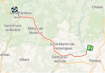

Length
16.7 km

Max alt
217 m

Uphill gradient
208 m
Km-Effort
19.7 km

Min alt
142 m

Downhill gradient
273 m
Boucle
No
Creation date :
2017-07-31 00:00:00.0
Updated on :
2017-07-31 00:00:00.0
2h00
Difficulty : Unknown

FREE GPS app for hiking
 SityTrail
IGN / Geographical institutes
SityTrail Plus
The world is yours!
About
Trail Cycle of 16.7 km to be discovered at New Aquitaine, Dordogne, Thiviers. This trail is proposed by d.rognon.
Positioning
Country:
France
Region :
New Aquitaine
Department/Province :
Dordogne
Municipality :
Thiviers
Location:
Unknown
Start:(Dec)
Start:(UTM)
335737 ; 5032766 (31T) N.
Comments