


Hike 2017 jour 1

albert318
User
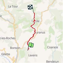

Length
14.7 km

Max alt
1207 m

Uphill gradient
1211 m
Km-Effort
29 km

Min alt
182 m

Downhill gradient
552 m
Boucle
No
Creation date :
2017-08-04 00:00:00.0
Updated on :
2017-08-04 00:00:00.0
6h27
Difficulty : Very difficult

FREE GPS app for hiking
 SityTrail
IGN / Geographical institutes
SityTrail Plus
The world is yours!
About
Trail Walking of 14.7 km to be discovered at Provence-Alpes-Côte d'Azur, Maritime Alps, Levens. This trail is proposed by albert318.
Description
Hike Mercantour: De Levens au col du Castel Gineste. Attention, plus de magasin à Utelle et pas de point d'eau dans la montagne
Positioning
Country:
France
Region :
Provence-Alpes-Côte d'Azur
Department/Province :
Maritime Alps
Municipality :
Levens
Location:
Unknown
Start:(Dec)
Start:(UTM)
357424 ; 4857565 (32T) N.
Comments