Puy Chopine - (Chanat)

Gegetop
User
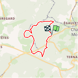

Length
11.7 km

Max alt
1093 m

Uphill gradient
289 m
Km-Effort
15.5 km

Min alt
867 m

Downhill gradient
289 m
Boucle
Yes
Creation date :
2018-01-18 00:00:00.0
Updated on :
2018-08-20 07:30:41.184
3h00
Difficulty : Easy

FREE GPS app for hiking
 SityTrail
IGN / Geographical institutes
SityTrail Plus
The world is yours!
About
Trail Walking of 11.7 km to be discovered at Auvergne-Rhône-Alpes, Puy-de-Dôme, Chanat-la-Mouteyre. This trail is proposed by Gegetop.
Description
Essai, enregistré sur le guide editor.


Positioning
Country:
France
Region :
Auvergne-Rhône-Alpes
Department/Province :
Puy-de-Dôme
Municipality :
Chanat-la-Mouteyre
Location:
Unknown
Start:(Dec)
Start:(UTM)
498699 ; 5074892 (31T) N.
Comments