


Amicale_Condrieu

d.rognon
User

Length
12.2 km

Max alt
404 m

Uphill gradient
291 m
Km-Effort
16 km

Min alt
149 m

Downhill gradient
291 m
Boucle
Yes
Creation date :
2017-08-05 00:00:00.0
Updated on :
2024-02-22 09:27:55.999
3h26
Difficulty : Medium

FREE GPS app for hiking
 SityTrail
IGN / Geographical institutes
SityTrail Plus
The world is yours!
About
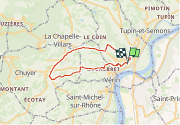
Trail Walking of 12.2 km to be discovered at Auvergne-Rhône-Alpes, Rhône, Condrieu. This trail is proposed by d.rognon.
Description
Forte montée au départ (dénivelé de 110 m sur une distance de 600 m
Randonnée effectuée le 25/4/23
Positioning
Country:
France
Region :
Auvergne-Rhône-Alpes
Department/Province :
Rhône
Municipality :
Condrieu
Location:
Unknown
Start:(Dec)
Start:(UTM)
637916 ; 5035713 (31T) N.
Comments