


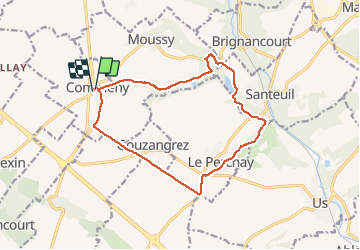
Commeny

csy95
User

Length
13.8 km

Max alt
118 m

Uphill gradient
139 m
Km-Effort
15.6 km

Min alt
53 m

Downhill gradient
139 m
Boucle
Yes
Creation date :
2018-08-26 10:57:47.652
Updated on :
2018-08-26 10:57:47.745
3h29
Difficulty : Easy

FREE GPS app for hiking
 SityTrail
IGN / Geographical institutes
SityTrail Plus
The world is yours!
About
Trail Walking of 13.8 km to be discovered at Ile-de-France, Val-d'Oise, Commeny. This trail is proposed by csy95.
Positioning
Country:
France
Region :
Ile-de-France
Department/Province :
Val-d'Oise
Municipality :
Commeny
Location:
Unknown
Start:(Dec)
Start:(UTM)
418995 ; 5442112 (31U) N.
Comments