


Mours-Royaumont-Mours

csy95
User
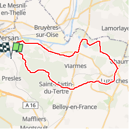

Length
31 km

Max alt
217 m

Uphill gradient
393 m
Km-Effort
37 km

Min alt
24 m

Downhill gradient
393 m
Boucle
Yes
Creation date :
2018-08-26 10:57:47.041
Updated on :
2018-08-26 10:57:47.078
2h06
Difficulty : Medium

FREE GPS app for hiking
 SityTrail
IGN / Geographical institutes
SityTrail Plus
The world is yours!
About
Trail Cycle of 31 km to be discovered at Ile-de-France, Val-d'Oise, Nointel. This trail is proposed by csy95.
Positioning
Country:
France
Region :
Ile-de-France
Department/Province :
Val-d'Oise
Municipality :
Nointel
Location:
Unknown
Start:(Dec)
Start:(UTM)
447556 ; 5442444 (31U) N.
Comments