


9 canal de Bourgogne confluent

BrassensJC
User

Length
23 km

Max alt
120 m

Uphill gradient
112 m
Km-Effort
25 km

Min alt
76 m

Downhill gradient
150 m
Boucle
No
Creation date :
2017-08-09 00:00:00.0
Updated on :
2017-08-09 00:00:00.0
5h00
Difficulty : Medium

FREE GPS app for hiking
 SityTrail
IGN / Geographical institutes
SityTrail Plus
The world is yours!
About
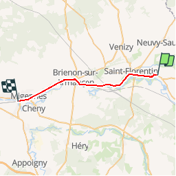
Trail Walking of 23 km to be discovered at Bourgogne-Franche-Comté, Yonne, Germigny. This trail is proposed by BrassensJC.
Description
arrivée à Migennes
Positioning
Country:
France
Region :
Bourgogne-Franche-Comté
Department/Province :
Yonne
Municipality :
Germigny
Location:
Unknown
Start:(Dec)
Start:(UTM)
558249 ; 5316051 (31T) N.
Comments