


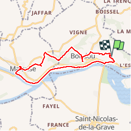
boucle route boudou - malause

Glurps
User

Length
14.9 km

Max alt
185 m

Uphill gradient
342 m
Km-Effort
19.5 km

Min alt
63 m

Downhill gradient
341 m
Boucle
Yes
Creation date :
2017-08-11 00:00:00.0
Updated on :
2017-08-11 00:00:00.0
3h58
Difficulty : Medium

FREE GPS app for hiking
 SityTrail
IGN / Geographical institutes
SityTrail Plus
The world is yours!
About
Trail Walking of 14.9 km to be discovered at Occitania, Tarn-et-Garonne, Boudou. This trail is proposed by Glurps.
Description
Des hauteurs descente vers Malause et retour par la veloroute entre les 2 canaux. Quelques belles montées
Positioning
Country:
France
Region :
Occitania
Department/Province :
Tarn-et-Garonne
Municipality :
Boudou
Location:
Unknown
Start:(Dec)
Start:(UTM)
342590 ; 4884479 (31T) N.
Comments