


Parnal (tour de la roche)

Patricelecerf
User
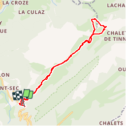

Length
19.4 km

Max alt
1735 m

Uphill gradient
1143 m
Km-Effort
35 km

Min alt
917 m

Downhill gradient
1120 m
Boucle
No
Creation date :
2017-08-14 00:00:00.0
Updated on :
2017-08-14 00:00:00.0
8h00
Difficulty : Medium

FREE GPS app for hiking
 SityTrail
IGN / Geographical institutes
SityTrail Plus
The world is yours!
About
Trail Other activity of 19.4 km to be discovered at Auvergne-Rhône-Alpes, Upper Savoy, Fillière. This trail is proposed by Patricelecerf.
Description
13.08.17
Physique 3
Technique 4 à cause du pas de la truie
Positioning
Country:
France
Region :
Auvergne-Rhône-Alpes
Department/Province :
Upper Savoy
Municipality :
Fillière
Location:
Thorens-Glières
Start:(Dec)
Start:(UTM)
290549 ; 5094286 (32T) N.
Comments