20170916-carolles A-M

doudet
User
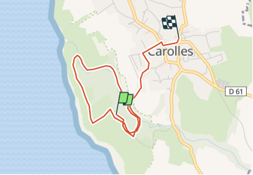

Length
3.8 km

Max alt
70 m

Uphill gradient
77 m
Km-Effort
4.9 km

Min alt
20 m

Downhill gradient
81 m
Boucle
No
Creation date :
2018-09-11 09:10:54.213
Updated on :
2018-09-11 09:10:54.213
1h30
Difficulty : Unknown

FREE GPS app for hiking
 SityTrail
IGN / Geographical institutes
SityTrail Plus
The world is yours!
About
Trail Other activity of 3.8 km to be discovered at Normandy, Manche, Carolles. This trail is proposed by doudet.
Positioning
Country:
France
Region :
Normandy
Department/Province :
Manche
Municipality :
Carolles
Location:
Unknown
Start:(Dec)
Start:(UTM)
605397 ; 5400047 (30U) N.
Comments