


wandignies warlaing et GR121 Bis

BrassensJC
User

Length
12.4 km

Max alt
23 m

Uphill gradient
44 m
Km-Effort
13 km

Min alt
13 m

Downhill gradient
44 m
Boucle
Yes
Creation date :
2017-08-15 00:00:00.0
Updated on :
2017-08-15 00:00:00.0
2h54
Difficulty : Easy

FREE GPS app for hiking
 SityTrail
IGN / Geographical institutes
SityTrail Plus
The world is yours!
About
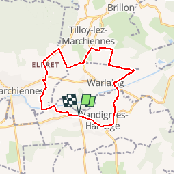
Trail Walking of 12.4 km to be discovered at Hauts-de-France, Nord, Wandignies-Hamage. This trail is proposed by BrassensJC.
Description
variante, retour par la route warlaing Wandignies
Positioning
Country:
France
Region :
Hauts-de-France
Department/Province :
Nord
Municipality :
Wandignies-Hamage
Location:
Unknown
Start:(Dec)
Start:(UTM)
522320 ; 5583091 (31U) N.
Comments