


tour du terril de Rieulay

BrassensJC
User
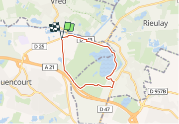

Length
4.8 km

Max alt
30 m

Uphill gradient
31 m
Km-Effort
5.3 km

Min alt
11 m

Downhill gradient
33 m
Boucle
Yes
Creation date :
2017-08-24 00:00:00.0
Updated on :
2017-08-24 00:00:00.0
1h12
Difficulty : Easy

FREE GPS app for hiking
 SityTrail
IGN / Geographical institutes
SityTrail Plus
The world is yours!
About
Trail Walking of 4.8 km to be discovered at Hauts-de-France, Nord, Pecquencourt. This trail is proposed by BrassensJC.
Positioning
Country:
France
Region :
Hauts-de-France
Department/Province :
Nord
Municipality :
Pecquencourt
Location:
Unknown
Start:(Dec)
Start:(UTM)
516647 ; 5581718 (31U) N.
Comments