


Cheval blanc

Patricelecerf
User
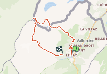

Length
18.8 km

Max alt
2821 m

Uphill gradient
1770 m
Km-Effort
42 km

Min alt
1349 m

Downhill gradient
1564 m
Boucle
No
Creation date :
2017-08-21 00:00:00.0
Updated on :
2017-08-21 00:00:00.0
11h33
Difficulty : Difficult

FREE GPS app for hiking
 SityTrail
IGN / Geographical institutes
SityTrail Plus
The world is yours!
About
Trail Walking of 18.8 km to be discovered at Auvergne-Rhône-Alpes, Upper Savoy, Vallorcine. This trail is proposed by Patricelecerf.
Description
18/19.08.2017
Physique 3
Technique 4
Positioning
Country:
France
Region :
Auvergne-Rhône-Alpes
Department/Province :
Upper Savoy
Municipality :
Vallorcine
Location:
Unknown
Start:(Dec)
Start:(UTM)
338759 ; 5098591 (32T) N.
Comments