


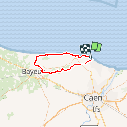
Boucle Plage du débarquement via Saint Aubin Manvieu Fontenaille Aulnay St Gabriel Brécy Creully Amblie et retour

lionelwalter
User

Length
58 km

Max alt
67 m

Uphill gradient
462 m
Km-Effort
64 km

Min alt
-1 m

Downhill gradient
464 m
Boucle
No
Creation date :
2018-04-16 00:00:00.0
Updated on :
2018-04-16 00:00:00.0
2h59
Difficulty : Very easy

FREE GPS app for hiking
 SityTrail
IGN / Geographical institutes
SityTrail Plus
The world is yours!
About
Trail Cycle of 58 km to be discovered at Normandy, Calvados, Saint-Aubin-sur-Mer. This trail is proposed by lionelwalter.
Description
60kms
Photos

Positioning
Country:
France
Region :
Normandy
Department/Province :
Calvados
Municipality :
Saint-Aubin-sur-Mer
Location:
Unknown
Start:(Dec)
Start:(UTM)
689734 ; 5467188 (30U) N.
Comments