


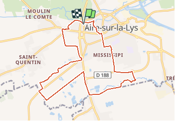
AIRE SUR LYS

ochelen
User

Length
9.4 km

Max alt
28 m

Uphill gradient
40 m
Km-Effort
9.9 km

Min alt
16 m

Downhill gradient
39 m
Boucle
Yes
Creation date :
2017-08-22 00:00:00.0
Updated on :
2017-08-22 00:00:00.0
2h14
Difficulty : Unknown

FREE GPS app for hiking
 SityTrail
IGN / Geographical institutes
SityTrail Plus
The world is yours!
About
Trail Walking of 9.4 km to be discovered at Hauts-de-France, Pas-de-Calais, Aire-sur-la-Lys. This trail is proposed by ochelen.
Positioning
Country:
France
Region :
Hauts-de-France
Department/Province :
Pas-de-Calais
Municipality :
Aire-sur-la-Lys
Location:
Unknown
Start:(Dec)
Start:(UTM)
456898 ; 5609989 (31U) N.
Comments