les planches Francis

yakout
User
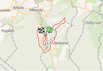

Length
14.4 km

Max alt
584 m

Uphill gradient
436 m
Km-Effort
20 km

Min alt
321 m

Downhill gradient
437 m
Boucle
Yes
Creation date :
2018-04-16 21:48:36.374
Updated on :
2018-04-16 21:48:36.374
4h56
Difficulty : Unknown

FREE GPS app for hiking
 SityTrail
IGN / Geographical institutes
SityTrail Plus
The world is yours!
About
Trail Other activity of 14.4 km to be discovered at Bourgogne-Franche-Comté, Jura, Les Planches-près-Arbois. This trail is proposed by yakout.
Positioning
Country:
France
Region :
Bourgogne-Franche-Comté
Department/Province :
Jura
Municipality :
Les Planches-près-Arbois
Location:
Unknown
Start:(Dec)
Start:(UTM)
713755 ; 5195539 (31T) N.
Comments