


st Martin

Djaie60
User
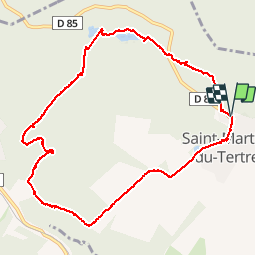

Length
10 km

Max alt
212 m

Uphill gradient
210 m
Km-Effort
12.8 km

Min alt
64 m

Downhill gradient
212 m
Boucle
Yes
Creation date :
2019-04-12 07:41:44.872
Updated on :
2019-04-12 07:41:44.938
2h35
Difficulty : Medium

FREE GPS app for hiking
 SityTrail
IGN / Geographical institutes
SityTrail Plus
The world is yours!
About
Trail Walking of 10 km to be discovered at Ile-de-France, Val-d'Oise, Saint-Martin-du-Tertre. This trail is proposed by Djaie60.
Positioning
Country:
France
Region :
Ile-de-France
Department/Province :
Val-d'Oise
Municipality :
Saint-Martin-du-Tertre
Location:
Unknown
Start:(Dec)
Start:(UTM)
452103 ; 5439881 (31U) N.
Comments