


meziere

coglais
User

Length
14.7 km

Max alt
100 m

Uphill gradient
250 m
Km-Effort
18 km

Min alt
43 m

Downhill gradient
250 m
Boucle
Yes
Creation date :
2018-04-16 22:20:29.64
Updated on :
2018-04-16 22:20:29.64
2h42
Difficulty : Unknown

FREE GPS app for hiking
 SityTrail
IGN / Geographical institutes
SityTrail Plus
The world is yours!
About
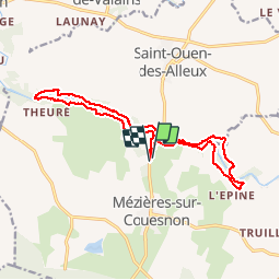
Trail Nordic walking of 14.7 km to be discovered at Brittany, Ille-et-Vilaine, Mézières-sur-Couesnon. This trail is proposed by coglais.
Positioning
Country:
France
Region :
Brittany
Department/Province :
Ille-et-Vilaine
Municipality :
Mézières-sur-Couesnon
Location:
Unknown
Start:(Dec)
Start:(UTM)
616257 ; 5351708 (30U) N.
Comments