


boucle Montgueux-Macey

DaVinci
User
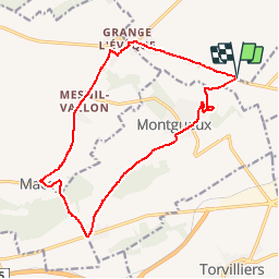

Length
15.4 km

Max alt
252 m

Uphill gradient
251 m
Km-Effort
18.8 km

Min alt
140 m

Downhill gradient
250 m
Boucle
Yes
Creation date :
2018-04-16 22:22:58.853
Updated on :
2018-04-16 22:22:58.853
1h05
Difficulty : Medium

FREE GPS app for hiking
 SityTrail
IGN / Geographical institutes
SityTrail Plus
The world is yours!
About
Trail Cycle of 15.4 km to be discovered at Grand Est, Aube, Saint-Lyé. This trail is proposed by DaVinci.
Positioning
Country:
France
Region :
Grand Est
Department/Province :
Aube
Municipality :
Saint-Lyé
Location:
Unknown
Start:(Dec)
Start:(UTM)
572461 ; 5351760 (31U) N.
Comments