


Mons près de Fayence

Michelisabelle
User
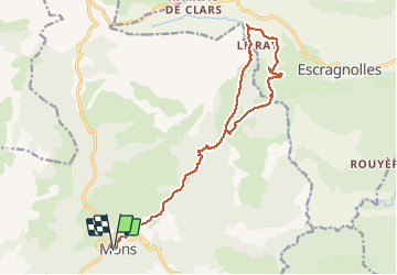

Length
18 km

Max alt
980 m

Uphill gradient
573 m
Km-Effort
26 km

Min alt
759 m

Downhill gradient
573 m
Boucle
Yes
Creation date :
2018-04-16 22:27:48.604
Updated on :
2018-04-16 22:27:48.604
5h00
Difficulty : Difficult

FREE GPS app for hiking
 SityTrail
IGN / Geographical institutes
SityTrail Plus
The world is yours!
About
Trail Other activity of 18 km to be discovered at Provence-Alpes-Côte d'Azur, Var, Mons. This trail is proposed by Michelisabelle.
Positioning
Country:
France
Region :
Provence-Alpes-Côte d'Azur
Department/Province :
Var
Municipality :
Mons
Location:
Unknown
Start:(Dec)
Start:(UTM)
315675 ; 4839939 (32T) N.
Comments