


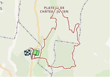
Saint martin en Vercors-La Baraque de Malaterre-Vercors

ThierryJ01
User

Length
11.3 km

Max alt
1531 m

Uphill gradient
531 m
Km-Effort
18.4 km

Min alt
1278 m

Downhill gradient
537 m
Boucle
Yes
Creation date :
2018-04-16 22:28:20.126
Updated on :
2020-10-18 15:45:34.661
3h55
Difficulty : Easy

FREE GPS app for hiking
 SityTrail
IGN / Geographical institutes
SityTrail Plus
The world is yours!
About
Trail Walking of 11.3 km to be discovered at Auvergne-Rhône-Alpes, Drôme, Saint-Martin-en-Vercors. This trail is proposed by ThierryJ01.
Positioning
Country:
France
Region :
Auvergne-Rhône-Alpes
Department/Province :
Drôme
Municipality :
Saint-Martin-en-Vercors
Location:
Unknown
Start:(Dec)
Start:(UTM)
694777 ; 4989121 (31T) N.
Comments