


Le chemin du Brion

jdelettrez
User

Length
11.8 km

Max alt
905 m

Uphill gradient
573 m
Km-Effort
19.4 km

Min alt
519 m

Downhill gradient
568 m
Boucle
Yes
Creation date :
2018-03-13 00:37:24.474
Updated on :
2018-03-13 00:37:24.474
3h59
Difficulty : Difficult

FREE GPS app for hiking
 SityTrail
IGN / Geographical institutes
SityTrail Plus
The world is yours!
About
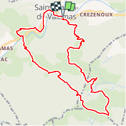
Trail Walking of 11.8 km to be discovered at Auvergne-Rhône-Alpes, Ardèche, Saint-Martin-de-Valamas. This trail is proposed by jdelettrez.
Description
Belle randonnée partant de ST Martin de Valamas qui monte dans la vallée du Trenc jusqu'au dyke du chateau de Brion.A voir
Positioning
Country:
France
Region :
Auvergne-Rhône-Alpes
Department/Province :
Ardèche
Municipality :
Saint-Martin-de-Valamas
Location:
Unknown
Start:(Dec)
Start:(UTM)
608188 ; 4976715 (31T) N.
Comments
a faire