Raddon-circuit court

geranimo
User

Length
15 km

Max alt
494 m

Uphill gradient
332 m
Km-Effort
19.5 km

Min alt
348 m

Downhill gradient
333 m
Boucle
Yes
Creation date :
2017-10-10 00:00:00.0
Updated on :
2017-10-10 00:00:00.0
4h08
Difficulty : Medium

FREE GPS app for hiking
 SityTrail
IGN / Geographical institutes
SityTrail Plus
The world is yours!
About
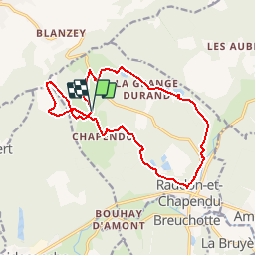
Trail Walking of 15 km to be discovered at Bourgogne-Franche-Comté, Haute-Saône, Raddon-et-Chapendu. This trail is proposed by geranimo.

Positioning
Country:
France
Region :
Bourgogne-Franche-Comté
Department/Province :
Haute-Saône
Municipality :
Raddon-et-Chapendu
Location:
Unknown
Start:(Dec)
Start:(UTM)
308242 ; 5303964 (32T) N.
Comments