


a l ombre de serignane

Coryphene
User

Length
9.9 km

Max alt
490 m

Uphill gradient
257 m
Km-Effort
13.3 km

Min alt
339 m

Downhill gradient
244 m
Boucle
No
Creation date :
2018-04-16 23:03:28.796
Updated on :
2019-09-24 16:38:10.259
4h58
Difficulty : Unknown

FREE GPS app for hiking
 SityTrail
IGN / Geographical institutes
SityTrail Plus
The world is yours!
About
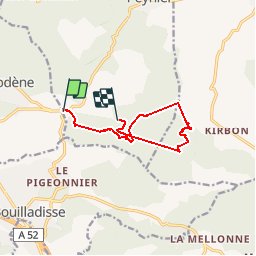
Trail Walking of 9.9 km to be discovered at Provence-Alpes-Côte d'Azur, Bouches-du-Rhône, Peynier. This trail is proposed by Coryphene.
Positioning
Country:
France
Region :
Provence-Alpes-Côte d'Azur
Department/Province :
Bouches-du-Rhône
Municipality :
Peynier
Location:
Unknown
Start:(Dec)
Start:(UTM)
711323 ; 4810615 (31T) N.
Comments