Trail Walking Valtournenche - Val d ayas  Breuil   Cervinia par col supériorité sine blanca   - Photo

Val d ayas Breuil Cervinia par col supériorité sine blanca

© OpenStreetMap contributors
Length
Length
10.5 km
Max alt
Max alt
2990 m
Uphill gradient
Uphill gradient
303 m
Km-Effort
Km-Effort  
17.9 km
Min alt
Min alt
1690 m
Downhill gradient
Downhill gradient
1307 m
Boucle
Boucle
No
Creation date :
2017-09-18 00:00:00.0
Updated on :
2017-09-18 00:00:00.0

(0 Reviews)

Walking
Walking
5h52
Difficulty : Unknown

Scan this QR Code to open this trail in the SityTrail application

FREE GPS app for hiking

Logo SityTrail SityTrail

IGN / Geographical institutes

Download SityTrail from the App Store Download SityTrail from Google Play

Logo SityTrail SityTrail World

The world is yours!

Download SityTrail from the App Store Download SityTrail from Google Play Download SityTrail on Huawei AppGallery

About

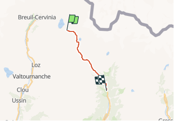
Trail Walking of 10.5 km to be discovered at Aosta Valley, Unknown, Valtournenche. This trail is proposed by chris13370.

Description

1350 m négatif

Elevation profile

Positioning

Country:
Italy
Region :
Aosta Valley
Department/Province :
Unknown
Municipality :
Valtournenche
Location:
Unknown
Start:(UTM)
397112 ; 5086311 (32T) N.

Trails nearby

Trail Other activity Zermatt - st_breithorn - Photo
Other activity
GUIDE+

Other activity

Very easy
(1)
Zermatt, Valais/Wallis, Visp, Switzerland
3.4 km | 7.1 km-effort
1h 41min
No
Trail On foot Valtournenche - Sentier Jean Antoine Carrel - 30 km - E/EE - Photo
On foot
PRO

On foot

Very difficult
Valtournenche, Aosta Valley, Unknown, Italy
27 km | 45 km-effort
10h 15min
Yes
Trail On foot Valtournenche - Itinerario 11 Rifugio Bobba Cervinia - Photo
On foot
PRO

On foot

Easy
Valtournenche, Aosta Valley, Unknown, Italy
4 km | 11.5 km-effort
2h 37min
No
Trail On foot Valtournenche - Itinerario 17 Breuil/Cervinia-Bec Pio Merlo - Photo
On foot
PRO

On foot

Easy
Valtournenche, Aosta Valley, Unknown, Italy
4.5 km | 10.7 km-effort
2h 25min
No
Trail Walking Valtournenche - Cheneil a Crepin via lago Doz - Photo
Walking
David Toussaint

Walking

Difficult
Valtournenche, Aosta Valley, Unknown, Italy
17.8 km | 31 km-effort
5h 12min
No
Trail On foot Valtournenche - Itinerario 23 Colle della Roisette - Photo
On foot
PRO

On foot

Easy
Valtournenche, Aosta Valley, Unknown, Italy
3.1 km | 4.9 km-effort
1h 7min
No
Trail Walking Zermatt - sf_e11cc - Photo
Walking
GUIDE+

Walking

Very easy
Zermatt, Valais/Wallis, Visp, Switzerland
3.4 km | 7.1 km-effort
1h 16min
No
Trail Walking Valtournenche - de Crepin à Chamois puis Cheneil - Photo
Walking
David Toussaint

Walking

Medium
Valtournenche, Aosta Valley, Unknown, Italy
12.5 km | 24 km-effort
5h 40min
No
Trail Walking Valtournenche - Lago Doz - Photo
Walking
David Toussaint

Walking

Easy
Valtournenche, Aosta Valley, Unknown, Italy
8.5 km | 12.4 km-effort
2h 55min
Yes


Close
My subscriptions