


La Face - Florac

nolsim
User
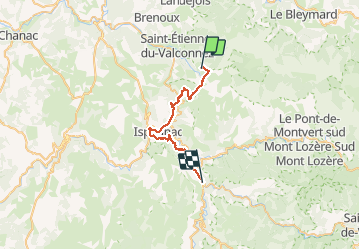

Length
30 km

Max alt
1256 m

Uphill gradient
575 m
Km-Effort
40 km

Min alt
503 m

Downhill gradient
1238 m
Boucle
No
Creation date :
2018-08-18 14:07:14.124
Updated on :
2018-08-18 14:07:14.124
8h35
Difficulty : Medium

FREE GPS app for hiking
 SityTrail
IGN / Geographical institutes
SityTrail Plus
The world is yours!
About
Trail Walking of 30 km to be discovered at Occitania, Lozère, Saint-Étienne-du-Valdonnez. This trail is proposed by nolsim.
Positioning
Country:
France
Region :
Occitania
Department/Province :
Lozère
Municipality :
Saint-Étienne-du-Valdonnez
Location:
Unknown
Start:(Dec)
Start:(UTM)
547323 ; 4920159 (31T) N.
Comments