


Sommet de Larran le Contadour

rigol05
User
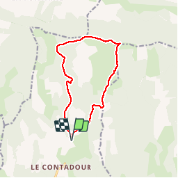

Length
12.6 km

Max alt
1424 m

Uphill gradient
339 m
Km-Effort
17.1 km

Min alt
1183 m

Downhill gradient
337 m
Boucle
Yes
Creation date :
2018-04-16 23:15:49.562
Updated on :
2018-04-16 23:15:49.562
3h42
Difficulty : Easy

FREE GPS app for hiking
 SityTrail
IGN / Geographical institutes
SityTrail Plus
The world is yours!
About
Trail Walking of 12.6 km to be discovered at Provence-Alpes-Côte d'Azur, Alpes-de-Haute-Provence, Redortiers. This trail is proposed by rigol05.
Positioning
Country:
France
Region :
Provence-Alpes-Côte d'Azur
Department/Province :
Alpes-de-Haute-Provence
Municipality :
Redortiers
Location:
Unknown
Start:(Dec)
Start:(UTM)
710000 ; 4887881 (31T) N.
Comments