


ALEX-VILLARDS DESSUS

COMAN
User
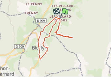

Length
8.6 km

Max alt
1029 m

Uphill gradient
450 m
Km-Effort
14.6 km

Min alt
668 m

Downhill gradient
450 m
Boucle
Yes
Creation date :
2018-04-16 23:38:08.862
Updated on :
2018-04-16 23:38:08.862
--
Difficulty : Medium

FREE GPS app for hiking
 SityTrail
IGN / Geographical institutes
SityTrail Plus
The world is yours!
About
Trail Walking of 8.6 km to be discovered at Auvergne-Rhône-Alpes, Upper Savoy, Alex. This trail is proposed by COMAN.
Positioning
Country:
France
Region :
Auvergne-Rhône-Alpes
Department/Province :
Upper Savoy
Municipality :
Alex
Location:
Unknown
Start:(Dec)
Start:(UTM)
285086 ; 5084481 (32T) N.
Comments