


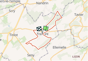
fraiture 13KM

ochelen
User

Length
13.6 km

Max alt
303 m

Uphill gradient
209 m
Km-Effort
16.4 km

Min alt
221 m

Downhill gradient
212 m
Boucle
Yes
Creation date :
2018-04-16 23:38:50.713
Updated on :
2018-04-16 23:38:50.713
10m
Difficulty : Unknown

FREE GPS app for hiking
 SityTrail
IGN / Geographical institutes
SityTrail Plus
The world is yours!
About
Trail Walking of 13.6 km to be discovered at Wallonia, Liège, Tinlot. This trail is proposed by ochelen.


Positioning
Country:
Belgium
Region :
Wallonia
Department/Province :
Liège
Municipality :
Tinlot
Location:
Fraiture
Start:(Dec)
Start:(UTM)
671637 ; 5594650 (31U) N.
Comments