


Abbaye de l'Etanche V2

PhilippeC54
User

Length
14.9 km

Max alt
414 m

Uphill gradient
312 m
Km-Effort
19.1 km

Min alt
260 m

Downhill gradient
319 m
Boucle
Yes
Creation date :
2018-04-16 23:46:05.771
Updated on :
2018-04-16 23:46:05.771
1h15
Difficulty : Unknown

FREE GPS app for hiking
 SityTrail
IGN / Geographical institutes
SityTrail Plus
The world is yours!
About
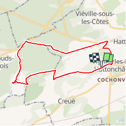
Trail Mountain bike of 14.9 km to be discovered at Grand Est, Meuse, Vigneulles-lès-Hattonchâtel. This trail is proposed by PhilippeC54.
Positioning
Country:
France
Region :
Grand Est
Department/Province :
Meuse
Municipality :
Vigneulles-lès-Hattonchâtel
Location:
Vigneulles-lès-Hattonchâtel
Start:(Dec)
Start:(UTM)
697219 ; 5428651 (31U) N.
Comments