


La Baume des Echelles Andon 3542 ET

verotrail
User

Length
17.6 km

Max alt
1488 m

Uphill gradient
472 m
Km-Effort
24 km

Min alt
1121 m

Downhill gradient
470 m
Boucle
Yes
Creation date :
2018-04-16 23:47:49.635
Updated on :
2018-04-16 23:47:49.635
5h13
Difficulty : Easy

FREE GPS app for hiking
 SityTrail
IGN / Geographical institutes
SityTrail Plus
The world is yours!
About
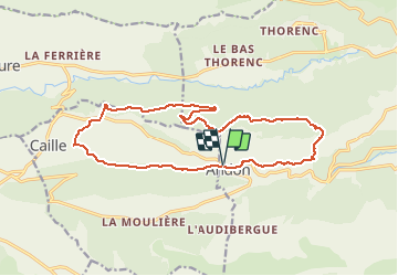
Trail Walking of 17.6 km to be discovered at Provence-Alpes-Côte d'Azur, Maritime Alps, Andon. This trail is proposed by verotrail.
Positioning
Country:
France
Region :
Provence-Alpes-Côte d'Azur
Department/Province :
Maritime Alps
Municipality :
Andon
Location:
Unknown
Start:(Dec)
Start:(UTM)
321686 ; 4849203 (32T) N.
Comments