


stavelot

henriantoine
User
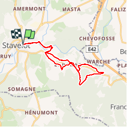

Length
13.4 km

Max alt
452 m

Uphill gradient
318 m
Km-Effort
17.7 km

Min alt
278 m

Downhill gradient
318 m
Boucle
Yes
Creation date :
2018-09-11 10:15:44.297
Updated on :
2018-09-11 10:15:44.297
3h40
Difficulty : Unknown

FREE GPS app for hiking
 SityTrail
IGN / Geographical institutes
SityTrail Plus
The world is yours!
About
Trail Walking of 13.4 km to be discovered at Wallonia, Liège, Stavelot. This trail is proposed by henriantoine.
Photos


Positioning
Country:
Belgium
Region :
Wallonia
Department/Province :
Liège
Municipality :
Stavelot
Location:
Stavelot
Start:(Dec)
Start:(UTM)
708666 ; 5586526 (31U) N.
Comments