


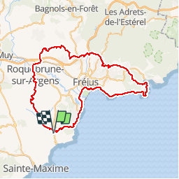
75km 905m VTT Roquebrune sur Argens - Esterel - Cap Dramont - Issambres

DHeusse
User

Length
75 km

Max alt
351 m

Uphill gradient
1278 m
Km-Effort
92 km

Min alt
0 m

Downhill gradient
1278 m
Boucle
Yes
Creation date :
2018-04-16 23:54:55.911
Updated on :
2018-04-16 23:54:55.911
5h48
Difficulty : Medium

FREE GPS app for hiking
 SityTrail
IGN / Geographical institutes
SityTrail Plus
The world is yours!
About
Trail Mountain bike of 75 km to be discovered at Provence-Alpes-Côte d'Azur, Var, Roquebrune-sur-Argens. This trail is proposed by DHeusse.
Positioning
Country:
France
Region :
Provence-Alpes-Côte d'Azur
Department/Province :
Var
Municipality :
Roquebrune-sur-Argens
Location:
Unknown
Start:(Dec)
Start:(UTM)
311504 ; 4803392 (32T) N.
Comments