


ORMOY VILLERS PIERRE GLISSOIRE

NUITEVEN
User
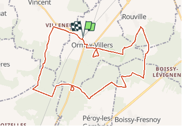

Length
21 km

Max alt
145 m

Uphill gradient
240 m
Km-Effort
25 km

Min alt
85 m

Downhill gradient
240 m
Boucle
Yes
Creation date :
2018-04-17 00:02:46.631
Updated on :
2018-04-17 00:02:46.631
5h49
Difficulty : Unknown

FREE GPS app for hiking
 SityTrail
IGN / Geographical institutes
SityTrail Plus
The world is yours!
About
Trail Walking of 21 km to be discovered at Hauts-de-France, Oise. This trail is proposed by NUITEVEN.
Positioning
Country:
France
Region :
Hauts-de-France
Department/Province :
Oise
Municipality :
ORMOY-VILLERS
Location:
Unknown
Start:(Dec)
Start:(UTM)
488190 ; 5449716 (31U) N.
Comments