


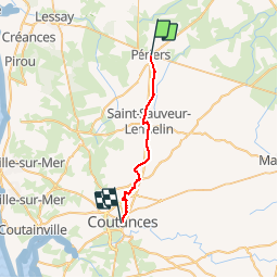
PERIERS COUTANCES

UDGI54
User

Length
19.6 km

Max alt
168 m

Uphill gradient
250 m
Km-Effort
23 km

Min alt
24 m

Downhill gradient
186 m
Boucle
No
Creation date :
2017-10-05 00:00:00.0
Updated on :
2017-10-05 00:00:00.0
4h59
Difficulty : Unknown

FREE GPS app for hiking
 SityTrail
IGN / Geographical institutes
SityTrail Plus
The world is yours!
About
Trail Walking of 19.6 km to be discovered at Normandy, Manche, Périers. This trail is proposed by UDGI54.
Positioning
Country:
France
Region :
Normandy
Department/Province :
Manche
Municipality :
Périers
Location:
Unknown
Start:(Dec)
Start:(UTM)
615960 ; 5449396 (30U) N.
Comments