


Crêtes de Chauvet

rigol05
User
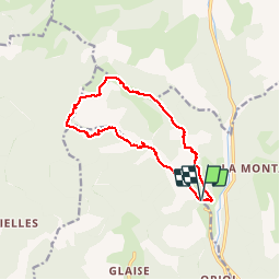

Length
12.6 km

Max alt
1636 m

Uphill gradient
721 m
Km-Effort
22 km

Min alt
967 m

Downhill gradient
719 m
Boucle
Yes
Creation date :
2018-04-17 00:08:12.444
Updated on :
2018-04-17 00:08:12.444
4h27
Difficulty : Medium

FREE GPS app for hiking
 SityTrail
IGN / Geographical institutes
SityTrail Plus
The world is yours!
About
Trail Walking of 12.6 km to be discovered at Provence-Alpes-Côte d'Azur, Hautes-Alpes, Montmaur. This trail is proposed by rigol05.
Description
Sortie du 05/10/2017
Belle randonnée, le passage entre le Villaret (ruine)et le Rocher Chabrière est délicat. Le sentier se perd dans le sous-bois, une trace gps facilite l'orientation.
Positioning
Country:
France
Region :
Provence-Alpes-Côte d'Azur
Department/Province :
Hautes-Alpes
Municipality :
Montmaur
Location:
Unknown
Start:(Dec)
Start:(UTM)
726051 ; 4941450 (31T) N.
Comments