


St-Cyr-en-Val_S20171006

lemuid
User
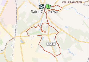

Length
11.1 km

Max alt
119 m

Uphill gradient
83 m
Km-Effort
12.2 km

Min alt
93 m

Downhill gradient
80 m
Boucle
Yes
Creation date :
2017-10-07 00:00:00.0
Updated on :
2017-10-07 00:00:00.0
2h14
Difficulty : Easy

FREE GPS app for hiking
 SityTrail
IGN / Geographical institutes
SityTrail Plus
The world is yours!
About
Trail Walking of 11.1 km to be discovered at Centre-Loire Valley, Loiret, Saint-Cyr-en-Val. This trail is proposed by lemuid.
Positioning
Country:
France
Region :
Centre-Loire Valley
Department/Province :
Loiret
Municipality :
Saint-Cyr-en-Val
Location:
Unknown
Start:(Dec)
Start:(UTM)
422786 ; 5298111 (31T) N.
Comments