


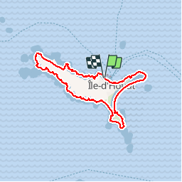
Île de Houat

nolsim
User

Length
14.4 km

Max alt
26 m

Uphill gradient
129 m
Km-Effort
16.1 km

Min alt
0 m

Downhill gradient
132 m
Boucle
Yes
Creation date :
2018-08-18 14:07:08.885
Updated on :
2018-08-18 14:07:08.885
3h57
Difficulty : Medium

FREE GPS app for hiking
 SityTrail
IGN / Geographical institutes
SityTrail Plus
The world is yours!
About
Trail Walking of 14.4 km to be discovered at Brittany, Morbihan, Île-d'Houat. This trail is proposed by nolsim.
Positioning
Country:
France
Region :
Brittany
Department/Province :
Morbihan
Municipality :
Île-d'Houat
Location:
Unknown
Start:(Dec)
Start:(UTM)
503127 ; 5248766 (30T) N.
Comments