


Bois d'Ecots

yannick-p
User
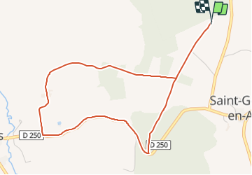

Length
4.9 km

Max alt
183 m

Uphill gradient
120 m
Km-Effort
6.5 km

Min alt
67 m

Downhill gradient
119 m
Boucle
Yes
Creation date :
2018-04-17 10:01:18.587
Updated on :
2021-07-19 09:20:11.462
2h00
Difficulty : Medium

FREE GPS app for hiking
 SityTrail
IGN / Geographical institutes
SityTrail Plus
The world is yours!
About
Trail Geocaching of 4.9 km to be discovered at Normandy, Calvados, Saint-Pierre-en-Auge. This trail is proposed by yannick-p.
Positioning
Country:
France
Region :
Normandy
Department/Province :
Calvados
Municipality :
Saint-Pierre-en-Auge
Location:
Unknown
Start:(Dec)
Start:(UTM)
284684 ; 5431403 (31U) N.
Comments