


treignes hierges

ameurant
User
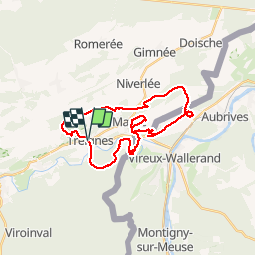

Length
26 km

Max alt
281 m

Uphill gradient
665 m
Km-Effort
35 km

Min alt
118 m

Downhill gradient
669 m
Boucle
Yes
Creation date :
2017-10-15 06:49:42.082
Updated on :
2017-10-15 06:49:42.082
5h50
Difficulty : Easy

FREE GPS app for hiking
 SityTrail
IGN / Geographical institutes
SityTrail Plus
The world is yours!
About
Trail Walking of 26 km to be discovered at Wallonia, Namur, Viroinval. This trail is proposed by ameurant.
Description
treignes hierges
Positioning
Country:
Belgium
Region :
Wallonia
Department/Province :
Namur
Municipality :
Viroinval
Location:
Treignes
Start:(Dec)
Start:(UTM)
619379 ; 5550273 (31U) N.
Comments