Trail Nordic walking Pontarmé - Pontarmé / Ermenonville - Photo

Pontarmé / Ermenonville

 domifon
domifon

User

© OpenStreetMap contributors
Length
Length
14.9 km
Max alt
Max alt
114 m
Uphill gradient
Uphill gradient
153 m
Km-Effort
Km-Effort  
16.9 km
Min alt
Min alt
53 m
Downhill gradient
Downhill gradient
152 m
Boucle
Boucle
Yes
Creation date :
2014-12-10 00:00:00.0
Updated on :
2014-12-10 00:00:00.0

(0 Reviews)

Nordic walking
Nordic walking
2h36
Difficulty : Medium

Scan this QR Code to open this trail in the SityTrail application

FREE GPS app for hiking

Logo SityTrail SityTrail

IGN / Geographical institutes

Download SityTrail from the App Store Download SityTrail from Google Play

Logo SityTrail SityTrail World

The world is yours!

Download SityTrail from the App Store Download SityTrail from Google Play Download SityTrail on Huawei AppGallery

About

Trail Nordic walking of 14.9 km to be discovered at Hauts-de-France, Oise, Pontarmé. This trail is proposed by domifon.

Description

Départ de Pontarmé et marche du coté du golf de Mortefontaine.
petits chemins très sympas surtout dans la partie Est

Elevation profile

Positioning

Country:
France
Region :
Hauts-de-France
Department/Province :
Oise
Municipality :
Pontarmé
Location:
Unknown
Start:(UTM)
467063 ; 5444900 (31U) N.

Trails nearby

Trail Walking Orry-la-Ville - Dans la forêt des moines - Orry-la-Ville - Photo
Walking
tracegps

Walking

Medium
(2)
Orry-la-Ville, Hauts-de-France, Oise, France
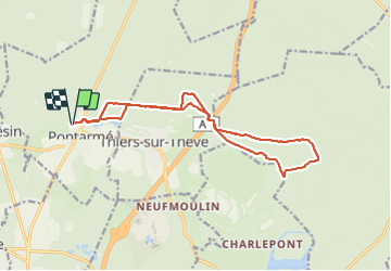
9.2 km | 11.2 km-effort
2h 30min
Yes
Trail Walking Orry-la-Ville - SM_MONTGRESIN_EST_8.2Km - Photo
Walking
GR77LP

Walking

Medium
(5)
Orry-la-Ville, Hauts-de-France, Oise, France
8.2 km | 9.2 km-effort
1h 51min
Yes
Trail Walking Senlis - SM_ERMENONVILLE Mais Forest BIAT_7.9Km - Photo
Walking
GR77LP

Walking

Medium
(2)
Senlis, Hauts-de-France, Oise, France
7.9 km | 8.9 km-effort
2h 1min
Yes
Trail Walking Thiers-sur-Thève - MR_THIERS-sur-THEVE_EST_La Pistole_5.9Km - Photo
Walking
GR77LP

Walking

Medium
(3)
Thiers-sur-Thève, Hauts-de-France, Oise, France
5.9 km | 6.6 km-effort
1h 30min
Yes
Trail Walking Pontarmé - MR_PONTARME-OUEST_4.9Km - Photo
Walking
GR77LP

Walking

Easy
(1)
Pontarmé, Hauts-de-France, Oise, France
4.9 km | 5.5 km-effort
1h 12min
Yes
Trail Walking Thiers-sur-Thève - MR_THIERS-sur-THEVE_5.3Km - Photo
Walking

Walking

Medium
(4)
Thiers-sur-Thève, Hauts-de-France, Oise, France
5.3 km | 6 km-effort
1h 22min
Yes
Trail Walking Thiers-sur-Thève - SM_THIERS-sur-THEVE_8.2Km  - Photo
Walking
GR77LP

Walking

Medium
(4)
Thiers-sur-Thève, Hauts-de-France, Oise, France
8.3 km | 9.2 km-effort
1h 57min
Yes
Trail Walking Pontarmé - SM_PONTARME_EST(Chateau)_8.6Km - Photo
Walking

Walking

Medium
(5)
Pontarmé, Hauts-de-France, Oise, France
8.6 km | 9.7 km-effort
2h 9min
Yes
Trail Walking Orry-la-Ville - La forêt des étangs de Comelle - Orry la Ville - Photo
Walking
tracegps

Walking

Medium
(1)
Orry-la-Ville, Hauts-de-France, Oise, France
11.4 km | 13 km-effort
4h 0min
Yes


Close
My subscriptions