


mont vial 1er elec

sylvainstaels
User
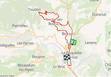

Length
39 km

Max alt
1530 m

Uphill gradient
1722 m
Km-Effort
62 km

Min alt
96 m

Downhill gradient
1662 m
Boucle
No
Creation date :
2018-04-17 10:06:58.538
Updated on :
2018-04-17 10:06:58.538
6h48
Difficulty : Difficult

FREE GPS app for hiking
 SityTrail
IGN / Geographical institutes
SityTrail Plus
The world is yours!
About
Trail Mountain bike of 39 km to be discovered at Provence-Alpes-Côte d'Azur, Maritime Alps, Gilette. This trail is proposed by sylvainstaels.
Positioning
Country:
France
Region :
Provence-Alpes-Côte d'Azur
Department/Province :
Maritime Alps
Municipality :
Gilette
Location:
Unknown
Start:(Dec)
Start:(UTM)
354580 ; 4855406 (32T) N.
Comments