


171004 EnCours

randodan
User
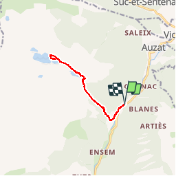

Length
12.3 km

Max alt
1646 m

Uphill gradient
915 m
Km-Effort
24 km

Min alt
828 m

Downhill gradient
912 m
Boucle
Yes
Creation date :
2018-04-17 10:07:34.68
Updated on :
2018-04-17 10:07:34.68
7h30
Difficulty : Unknown

FREE GPS app for hiking
 SityTrail
IGN / Geographical institutes
SityTrail Plus
The world is yours!
About
Trail Walking of 12.3 km to be discovered at Occitania, Ariège, Auzat. This trail is proposed by randodan.
Description
- 4 octobre - Étangs de Bassiès -<br>En cours
Photos


38 photos in total. Please click on a photo to see them all in the gallery.
Positioning
Country:
France
Region :
Occitania
Department/Province :
Ariège
Municipality :
Auzat
Location:
Unknown
Start:(Dec)
Start:(UTM)
374363 ; 4733603 (31T) N.
Comments