


les avins

colsonandre
User
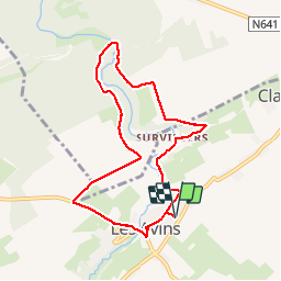

Length
7.6 km

Max alt
259 m

Uphill gradient
137 m
Km-Effort
9.4 km

Min alt
199 m

Downhill gradient
137 m
Boucle
Yes
Creation date :
2017-10-09 00:00:00.0
Updated on :
2019-08-10 18:20:12.823
2h28
Difficulty : Unknown

FREE GPS app for hiking
 SityTrail
IGN / Geographical institutes
SityTrail Plus
The world is yours!
About
Trail Walking of 7.6 km to be discovered at Wallonia, Liège, Clavier. This trail is proposed by colsonandre.
Positioning
Country:
Belgium
Region :
Wallonia
Department/Province :
Liège
Municipality :
Clavier
Location:
Les Avins
Start:(Dec)
Start:(UTM)
663700 ; 5587468 (31U) N.
Comments