


plan du var reveston col du vial

sylvainstaels
User
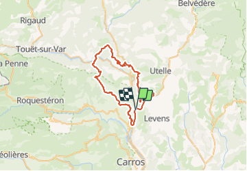

Length
59 km

Max alt
1253 m

Uphill gradient
2982 m
Km-Effort
98 km

Min alt
116 m

Downhill gradient
2997 m
Boucle
Yes
Creation date :
2018-04-17 10:30:30.901
Updated on :
2018-04-17 10:30:30.901
5h53
Difficulty : Difficult

FREE GPS app for hiking
 SityTrail
IGN / Geographical institutes
SityTrail Plus
The world is yours!
About
Trail Mountain bike of 59 km to be discovered at Provence-Alpes-Côte d'Azur, Maritime Alps, Utelle. This trail is proposed by sylvainstaels.
Positioning
Country:
France
Region :
Provence-Alpes-Côte d'Azur
Department/Province :
Maritime Alps
Municipality :
Utelle
Location:
Unknown
Start:(Dec)
Start:(UTM)
355286 ; 4857976 (32T) N.
Comments