


Sommets de Charouille & de la Fayée

rigol05
User
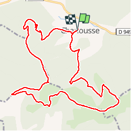

Length
13.5 km

Max alt
1288 m

Uphill gradient
718 m
Km-Effort
23 km

Min alt
779 m

Downhill gradient
718 m
Boucle
Yes
Creation date :
2018-04-17 10:34:09.99
Updated on :
2018-04-17 10:34:09.99
4h56
Difficulty : Medium

FREE GPS app for hiking
 SityTrail
IGN / Geographical institutes
SityTrail Plus
The world is yours!
About
Trail Walking of 13.5 km to be discovered at Provence-Alpes-Côte d'Azur, Hautes-Alpes, Chanousse. This trail is proposed by rigol05.
Description
Sortie du 12/10/2017
Positioning
Country:
France
Region :
Provence-Alpes-Côte d'Azur
Department/Province :
Hautes-Alpes
Municipality :
Chanousse
Location:
Unknown
Start:(Dec)
Start:(UTM)
711647 ; 4914776 (31T) N.
Comments
Très belle randonnée aux paysages variés.