


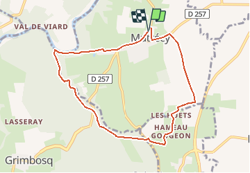
Mutrecy

gr1346
User

Length
8.1 km

Max alt
110 m

Uphill gradient
103 m
Km-Effort
9.5 km

Min alt
15 m

Downhill gradient
103 m
Boucle
Yes
Creation date :
2018-04-17 10:34:32.178
Updated on :
2021-02-25 16:50:27.488
2h55
Difficulty : Medium

FREE GPS app for hiking
 SityTrail
IGN / Geographical institutes
SityTrail Plus
The world is yours!
About
Trail Walking of 8.1 km to be discovered at Normandy, Calvados, Mutrécy. This trail is proposed by gr1346.
Positioning
Country:
France
Region :
Normandy
Department/Province :
Calvados
Municipality :
Mutrécy
Location:
Unknown
Start:(Dec)
Start:(UTM)
688364 ; 5437917 (30U) N.
Comments
Un peu de route.