


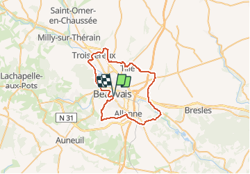
Autour de Beauvais

csy95
User

Length
45 km

Max alt
167 m

Uphill gradient
457 m
Km-Effort
51 km

Min alt
50 m

Downhill gradient
456 m
Boucle
Yes
Creation date :
2018-08-26 10:57:45.942
Updated on :
2018-09-02 09:56:10.466
2h46
Difficulty : Easy

FREE GPS app for hiking
 SityTrail
IGN / Geographical institutes
SityTrail Plus
The world is yours!
About
Trail Cycle of 45 km to be discovered at Hauts-de-France, Oise, Beauvais. This trail is proposed by csy95.
Positioning
Country:
France
Region :
Hauts-de-France
Department/Province :
Oise
Municipality :
Beauvais
Location:
Unknown
Start:(Dec)
Start:(UTM)
433736 ; 5475308 (31U) N.
Comments