


Etretat Vattetot sur mer

kikidenis1
User
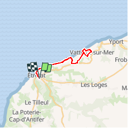

Length
16.7 km

Max alt
97 m

Uphill gradient
297 m
Km-Effort
21 km

Min alt
7 m

Downhill gradient
296 m
Boucle
Yes
Creation date :
2018-04-17 10:58:08.021
Updated on :
2018-04-17 10:58:08.021
4h49
Difficulty : Easy

FREE GPS app for hiking
 SityTrail
IGN / Geographical institutes
SityTrail Plus
The world is yours!
About
Trail Walking of 16.7 km to be discovered at Normandy, Seine-Maritime, Étretat. This trail is proposed by kikidenis1.
Description
Promenade sur les falaises
Positioning
Country:
France
Region :
Normandy
Department/Province :
Seine-Maritime
Municipality :
Étretat
Location:
Unknown
Start:(Dec)
Start:(UTM)
298743 ; 5509560 (31U) N.
Comments