PlanqueryCahagnoles

rollondesbois
User
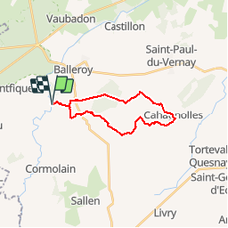

Length
18.3 km

Max alt
152 m

Uphill gradient
207 m
Km-Effort
21 km

Min alt
69 m

Downhill gradient
206 m
Boucle
Yes
Creation date :
2018-04-17 11:01:22.397
Updated on :
2018-04-17 11:01:22.397
4h37
Difficulty : Medium

FREE GPS app for hiking
 SityTrail
IGN / Geographical institutes
SityTrail Plus
The world is yours!
About
Trail Walking of 18.3 km to be discovered at Normandy, Calvados, Planquery. This trail is proposed by rollondesbois.
Description
Des étangs de Planquery au camping de Cahagnoles (parfait pour faire une pause) et retour
Positioning
Country:
France
Region :
Normandy
Department/Province :
Calvados
Municipality :
Planquery
Location:
Unknown
Start:(Dec)
Start:(UTM)
656530 ; 5447824 (30U) N.
Comments